Traveling and hiking are a part of everyone's life. For some, a trip to a neighboring city is enough, others plan to cross the mountains, and the third group leaves for other countries. Certain professions are related to orienteering. These are pilots and sailors. In any case, everyone plans their trip in advance, draws up a route, and determines the pass points.
It becomes very unpleasant when a trip to the forest to pick mushrooms or just for the sake of adventure is overshadowed by wanderings and anxiety. In such a situation, a compass and maps come to the rescue. Having them at hand, you will get out of the unknown surroundings to civilization without much difficulty. It is important to understand what it is, what it is needed for and learn how to properly use a compass in the forest without a map.
How does a compass work?
This is a small device, in the center of which an arrow is attached to a thin needle. It makes rotational movements exactly parallel to the Earth's force lines, which are surrounded by magnetic fields. The discovery is listed among the four most important and valuable achievements of Chinese scientists. In terms of its value, it can be compared with the invention of gunpowder, paper and textile printing. Modern models have been improved and have some variations. However, the principle of how to use the compass remains the same.
Let's take a closer look at how a compass works:
- The classic version is round. Mostly metal and plastic models are sold. They are not made of iron. They are made from copper and aluminum. Models with reinforced housings are also available.
- The dial is visible under the glass cover. Its second name is limbo . The designations of the sides of the horizon are recorded on it. Also, the division on the compass is indicated in ascending order - degrees. Zero on the compass is north, 90 is east on the compass, 180 is south, 270 is west. The countdown is clockwise.
- The compass needle is also located under the cover. It is placed on a thin pin to make the movement as easy and precise as possible. Often there is a two-color version, where the red arrow on the compass shows the north direction. However, compliance with such a rule falls only on the shoulders of the manufacturer.
- A lock is a mechanical locking lever designed to hold the arrow during non-working moments. When it descends, the compass needle is immediately freed and begins to seek north.
- The classic version is complemented by an outer ring designed to establish a movement reference. In modern models, the ring is replaced by a human-controlled arrow. Devices with a ruler and a map are also available. Sometimes they are supplemented with a magnifying glass.
Destruction of associative connections
The presence of connections between the model and its image allows you to constantly monitor their correspondence to each other, but at the same time makes it impossible to manually edit geometric objects in associative views.
Whenever you open drawings that contain associative views, the system checks for a match between the image and the model. If discrepancies are detected, a request is issued to rebuild the geometric objects of the drawing. If the product is complex, then both checking and rebuilding can take considerable time. Therefore, at the stage of drawing up drawings or after finishing work on them, when the connection with the model is no longer necessary, a technique such as breaking the associative connections between views and models can be used.
After destruction, the associative view turns into a set of primitives (segments, arcs, etc.) and becomes a regular user view of the KOMPAS-GRAPHIC drawing.
When is a compass better than a navigator?
New gadgets are invented and released for sale every day. One of these fashionable devices is GPS navigators . It contains a map and route planning function. Communication with the satellite allows you to accurately determine the location of the traveler and accompanies him throughout the entire route.
The main disadvantage of this gadget is the battery. It may shrink or break unexpectedly. In this case, the tourist will not be able to obtain any data about his location.
The GPS navigator includes a map and route planning function.
It’s easier in this regard with a tourist compass and a geographical map. They do not depend on the battery capacity, and the needle readings are accurate in nature.
It is important to remember to keep the device away from electronics, magnets and metals. The only difficulty is knowing the rules for reading a map, the basics of drawing a route and the rules for using a compass.
The cardinal directions are... What are the cardinal directions?
The request for "Southwest" is redirected here; see also other meanings.
- In geography, the cardinal direction
is one of the four main directions (north, south, west, east). - The directions north and south are determined by the Earth's poles, and west and east by the rotation of the planet around its axis.
- On modern geographical maps, the north side is always at the top, in this case the south is at the bottom, the west is on the left, and the east is on the right.
- Since ancient times, people have determined the approximate southern direction by the position of the sun at its zenith, the eastern direction by the place of sunrise, and the western direction by the place of sunset.
- The principle of four sides was an important milestone in man's knowledge of the world around him.
- Ancient maps, unlike modern ones, were oriented to the south.
When orienting a person in space, the principle of four sides is also used: “in front”, “behind”, “left”, “right”. In this case, the directions are not fixed and are chosen relative to the person himself.
The principle of fourfoldness is reflected in the folklore, customs, and religious rituals of many peoples, including Slavic ones:
- “go to all four directions”;
- Trypillian four-part altars were precisely oriented with their four crosses to the cardinal points, even if this direction diverged from the orientation of the walls of the house, etc.
Colors symbolizing cardinal directions
The traditional painting of the south end of the magnetic compass needle with red and the north end with black colors is an echo of ancient times. In the Assyrian calendar, the north was called the Black Country, the south was the Red Country, the east was the Green Country, and the west was the White Country. City gates in ancient China were painted accordingly.
Symbol
To designate the cardinal directions, 4 Latin letters are often used: N, S, E, W, which corresponds to the first letters of the names of the cardinal directions in English - North (north), South (south), East (east), West (west).
How to navigate with a compass
Move away from electronics and metal congestion. To begin orientation, you need to remove the arrow from the clamp. It will perform several rotational movements, stabilize and point north.
Once you know the direction, adjust your map exactly to the compass. Select some objects and compare what you see with your map.
Once you have determined your position, you need to determine your destination and create a route. To do this, compare the north of the map and your device, and indicate the direction.
Designations on the compass cardinal directions
The notation system uses the first letters. For example, Russian manufacturers often use N - north, S - south, E - east, W - west.
The international system assumes the use of the Latin alphabet: North (N - north), South (S - south), East (E - east), West (W - west).
This is a simplified version. It is acceptable to indicate intermediate values on the dial.
How to calculate cardinal directions
Looking at and studying the map in detail, we know that north is drawn at the top and south at the bottom. In this case, the location of the cardinal points can only be approximately calculated. With a compass, things are a little different. The compass needle is not fixed and does not indicate the location of your position and other objects on the map. It is required to identify cardinal directions.
The magnetized part of the rotating needle always points north. The second half is to the south. In various scientific publications there is often an indication that the northern part is blue. In other sources - red. In practice, it can even be multi-colored. To avoid errors, you must independently determine the magnetized half. This will further ensure that your compass is working properly.
To explore, go outside with your device at noon. Until 12.00 the sun is located near the southern direction. The half that faces the sun is south.
How to navigate by the sun and the clock is described in more detail in the article “How to navigate in the forest by the sun and the clock.”
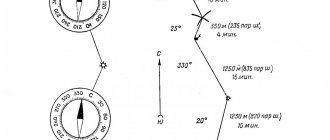
How to find azimuth using a compass
Azimuth is the angle between north and your destination, measured in degrees.
Procedure to determine azimuth:
- Place the device horizontally.
- The arrow descends from the latch.
- When the needle stabilizes and stops oscillating, it is aligned with the C (S) value on the dial.
- Select your destination. Align with the degrees on the compass.
- Calculate the given angle and strictly follow it. Try not to deviate.
Following the data received, the tourist will accurately reach the goal. To return, a reverse azimuth is taken - you need to go in the opposite direction.
Determining compass position without a map
The compass also makes it possible not to get lost in an unfamiliar forest without a map. Choose an object that will become a guide for you. It is better if it is an extended object - a road or a river.
Then you need to move into the forest perpendicular to the selected object. At the same time, it must be visible to the traveler.
Avid hikers often purchase transparent compasses. They are much more convenient when working with maps, and the drawn lines and contours greatly simplify orientation with a compass on the ground.
Next, work with the compass begins. It is placed on a flat surface and the arrow is activated. As soon as the arrow stabilizes, it is compared with the north. Draw a mental line to the object. The fixed value is the return azimuth for return.
Note! When moving in a wooded area, it is important to monitor deviations from the chosen course and try to avoid them.
To return, you need to take the compass so that the front sight points directly ahead.
Orientation by compass and map
If you are planning a long trip, and your destination is located far from a city or village, then it would be a good idea to stock up on a map, compass, ruler and pencil, and learn how a compass works. Many travelers research the area in advance.
Procedure:
- Place the map strictly horizontally and mark all the places you plan to visit.
- Next, place the device on the card and activate the arrow.
- Align the northern half of the arrow with the same value on the geographic map.
- Using a ruler, draw a line between the first stop on the route sheet and the middle of the dial. Calculate the heading azimuth to the first selected point. It is recommended to immediately record the return azimuth in the records.
- Next, mark all the selected points in this way.
- When you hit the road, keep an eye on your data.
When planning stops at several points, all measurements are made in advance, since this will take up valuable time along the way.
Having made preliminary calculations, you can not be afraid of getting lost even in an unfamiliar or wooded area.
Device
The design of the device seems complicated at first glance. Determining the cardinal directions using a compass is carried out thanks to special markings and many moving components. Lens models consist of several basic elements:
- Lid. Serves to protect the floating dial from damage. Consists of luminous aiming dots and threads.
- The basis. Contains several moving components. The floating dial is located in the middle, rotates freely, and there are luminous figures in the form of arrows and letters. The outer scale indicates millimeters, the inner scale indicates degrees. The frame is glass with a fixed line indicator. The frame ring makes a characteristic crackling sound when moving. Each of them is equal to 3º. One full circle contains 120 clicks.
- Rear sight. Data indicating the cardinal directions is read from the dial using this component. Objects are detected using an aiming slit and a front sight. The rear one closes the device; for operation it is necessary to open it more than 45º.
The markings on the compass are always the same, but the equipment is different. The most complex are considered to be military devices, which have a solid body, a lid with glass inserts, and a dial that glows in the dark. The devices are often equipped with a clinometer, a thread for fixing on a tripod, and a bubble level.
Specifics of using compasses
The principle of operation with some devices may be a little specific. First of all, it is necessary to select from the total mass those devices in which the arrow is glued to the dial. This greatly simplifies the task, because now you don’t have to combine the arrow and the north. Many tourists note the convenience of such a device. However, it is slightly slower than its simplified predecessor.
Another option is complemented by a small mirror. It is designed to control the measurements of the magnetic needle relative to the scale.
Avid tourists often purchase transparent ones. They are much more convenient when working with maps, and the drawn lines and contours greatly simplify orientation with a compass on the ground. Using it you can calculate the true azimuth. In this case, the work will not depend on nearby magnets, cars or electrical appliances.
Also in products for tourists you can find options with liquid in a flask. There are no differences in the functioning of devices with air.
Military, army or artillery models are distinguished as a separate category. They differ significantly from an amateur device. The military compass is made of impact-resistant material, and the needle stabilizes much more clearly and quickly. These two seemingly insignificant differences greatly simplify the work.
Compass error, magnetic declination
Geographic poles do not always coincide with magnetic poles. This phenomenon is associated with the laws of terrestrial magnetism and was discovered back in the 19th century. This fact has already been taken into account in electronic devices and on maps.
The north magnetic pole is located 700 miles from the geographic pole, while at the same time a deviation of 1,500 miles is recorded in the southern hemisphere. The difference, namely the angle formed between the indicators, is called magnetic declination.
The anomaly has been recorded in every part of our planet. For the most part, the differences are minor and do not require adjustment. In some areas the error can reach 25 degrees. To calculate the direction in this case, you must rely on information from the map.
Note! Due to the constant movement of the Earth and the displacement of layers, the values change. Therefore, it is recommended to update the maps periodically.
What to do if the compass does break?
The first thing a tourist needs to do is calm down. A breakdown even in unfamiliar surroundings is not a problem or a death sentence. This device can be easily built independently from scrap materials that an experienced tourist always has:
- sewing needle;
- bottom of a plastic bottle;
- a piece of tree bark or cork (about 3x3 cm in size);
- battery or magnet.
It is necessary to make a groove in a wooden cork or bark where the needle will later fit. The needle must be magnetized. This is done in one of 2 ways:
- One end is applied to a magnet, and the other is brought to a lit match. This is necessary to demagnetize the second half.
- Take a needle with insulated wire and attach different ends to different poles of the battery. That edge that touched the negative value will point to the north.
Next, the needle is placed in a groove, which in turn descends into the bottom of the lid with water. It will take some time. The improvised arrow will make several rotations and point north.
Setting up section symbols
Connecting a dimmer (light brightness control)
Creation of cross-section symbols is carried out through the menu Tools → Symbols → Cut line or using the Cut line command on the Symbols toolbar. At the beginning of the command, you must select the point to place the first symbol of the cut arrow. Then you need to determine what type of cut will be shown - simple or complex (with a broken cut line). If you intend to show a simple cut, then you must then indicate the point of placement of the second cut arrow symbol. If you intend to show a complex section, then you must first click the Complex section button and sequentially indicate the placement points of the bends of the complex section. The second cut arrow symbol will always be placed at the last point. To complete entering a complex section, press the Complex section button.
Next, you should enter the letter designation of the section, if it is not set automatically. When you click the Text field, the Enter Text dialog box appears. In which you can manually fill in text fields. The first field is the letter designation of the section. The second field is additional information (for example, the number of the sheet on which the cut is located).
If you check the Auto sort option, the program will automatically assign a symbol to indicate the section. This option may not be available if in the Tools → Options menu on the Current Document tab, in the Auto Sort section, the Auto Sort option is unchecked. Enabling the Sheet and Zone options automatically places the sheet number. Where the incision is placed. Or zone designation in the additional field of the section symbol. Using the Placement group of buttons, you can set the placement of additional information at the first or second arrow of the section.
After these operations, it is necessary to choose the direction of view of the incision. To do this, move the mouse across the cut line in one direction or another. you need to achieve the desired location of the gaze arrows and press the left mouse button or the Enter key.
Then the program offers to place a letter designating the view with a section. In this case, it is proposed to configure 2 tabs: on the Parameters tab, settings are made for the parameters of the new sectional view, and on the View Designation tab, settings for the text commentary for the sectional view are made.
- — Cut line command
- — Button Complex cut
- — Buttons Placement
Types of compasses
When choosing a compass, you need to rely on your needs, goals and some fundamental points of their use.
Magnetic
This is the simplest and long-known device. Its second name is Adrianov, in honor of the name of the Russian engineer-inventor. It is made of a metal or plastic body. Inside this case there is a dial indicating the cardinal directions and degrees. The cardinal directions are determined by a magnetized arrow. It interacts with the Earth's magnetic field.
There may be ordinary air or water inside the case. Some models are equipped with a lock that holds the arrow while the compass is not in use. Magnetic is the most widespread device among experienced tourists and amateurs.
Electromagnetic
Electromagnetic ones are used in cars, airplanes and ships. The action is carried out due to magnetic induction.
Operation does not depend on nearby electrical appliances, metals or magnets. This feature allows you to calculate the route with the smallest error.
Electronic
Electronic is an achievement of modern technological progress. The principle of operation is similar to the navigator. The device is battery powered and receives the signal from the satellite. The technique takes into account all errors and magnetic declinations. That is, they are the most accurate.
The only drawback is the possibility of battery discharge, which prevents use on a long hike where there is no way to charge the gadget.
Gyroscopic
The functioning of the device is ensured by a gyroscope. This is a device that responds to changes in orientation angle. Most often, such models are found in shipping and rocketry.
How to use a military compass
Military models are considered to be the most accurate measuring instruments. The compass body is made of metal, which ensures shock resistance and reliability when carrying out important military assignments.
Another plus is that the case is sealed and waterproof. Some will not lose their qualities even at depth. However, you can also find non-sealed ones on sale - the choice depends on the conditions in which you will use the selected device. After all, even an experienced tourist may be interested in purchasing a military device. For a novice traveler, the difference will not be noticeable.
Military compass.
The principle of operation does not differ from the operation of a regular tourist one, but however, it is recommended to read the instructions in advance.
As an additional element, they have a built-in ruler to make working with maps easier. To take accurate measurements, some models are equipped with a magnifying loupe and a viewfinder. Such a device will help make accurate calculations and set the right course for further movement.
Long life, impact resistance, affordability, simplicity and ability to be used in a wide range of weather conditions make military a popular option among terrain navigation products.
Advantages and disadvantages of GPS
In the digital age, more and more travelers are abandoning paper maps in favor of electronics. We will compare what is better and more convenient, and what to give preference to.
The advantages of GPS include:
- Excellent orientation in conditions of poor visibility, fog, snow, accurately determine the path;
- Support for local regional maps;
- Loading already laid routes with all the necessary marks;
- Visualization of completed tracks, uploading them to the Internet.
Of the minuses, we note the following:
- Skills and ability to work with a map become dull;
- Dependency on power supply;
- Possibility of signal loss.
Technology is constantly evolving, and something new and better appears every day. The same applies to orientation and navigation devices. And whatever they are, the basic basis is the principle of how and due to what the compass works.